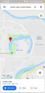
Omaha – Carter Lake
I’m going to the airport soon, the one on the right hand side of the above map. But I thought that Carter Lake, in the centre of the map, was intriguing because of the state boundaries. The lines through the middle show that Carter Lake is part of Iowa, even though it’s clearly in what is otherwise Nebraska territory. The ox-bow lake is the clue, the area flooded in 1877 and the river line drawn up dividing the states changed.
There were arguments for some years as to what state the area should be in, as when the river shifts then the boundary shifts. However, this wasn’t classed as a river shift and in 1892 the area was confirmed as being part of Iowa. It remains today as the only city in Iowa which is to the west of the Missouri River.

