Streets of Norwich – Barrack Street
Part of my Streets of Norwich project….
Barrack Street at the beginning of the twentieth century and the road line is still there, although the junction at Cowgate is now a large roundabout. It’s named after the cavalry barracks that are still visible on the above map.
Starting at the Cowgate / St. Crispins Road roundabout.
St James the Less Church, which is perhaps better known today as Norwich Puppet Theatre. More on this church in another post, as I’ve been on a guided tour of the church and I have photos somewhere of that. This is pretty much all of old Norwich that has survived the mauling about of Barrack Street and the church looks a bit lost today.
More recently, this has been a light industrial area with an ugly building facing the road. It’s now a housing development being built by Hill.
At the moment, these buildings have been left looking rather forlorn. It’s the two white buildings at 77-79 Barrack Street that are interesting, they’re listed (which probably annoys the owners) and are terraced houses dating from the beginning of the nineteenth century. As long as no-one has nicked them, the interiors are also important, with a cast-iron hob grate within a timber surround and a rare fireplace inside them. The premises were used as a fish and chip shop until recently, they’re really not in a good state externally.
Opposite these properties on the other side of the road is Bargate Court, but more on this in a later post.
This is now the head office of QD.
And the other side of the building and the paved area on the right is the entrance to what was once Pockthorpe Brewery, which was a substantial complex of buildings. When they built houses here in 1976, they did an archaeological survey and probably started with some high hopes of finding something new. The report stated “we revealed no finds or features of archaeological interest”. Thrilling. But best to check.
A few years ago they pulled down some council housing, which was in perfectly good nick, and then left the site vacant for years. It wasn’t a good look…. It’s part of the same Hill housing development which is now finally under construction and it’ll be known as St. James’s Quay.
Now a dentists, this was the Sportman pub from the early nineteenth century until its closure in 1995, when it was used as a solicitors. It replaced a pub of the same name which was located across the road.
And yet more of the Hill site that will be housing in the next few years. There’s not a huge amount of history lost here, as previously it was a light industrial site for some time and before then it was a timber yard and wharf area.
The former barracks site, now turned into generic looking housing. It’s a little unfortunate that they demolished the barracks in the 1960s, as the site would have made for an impressive museum location. Although the city council would probably only turned it into another bloody car park, so perhaps it’s better that it’s housing.
The barrack site again, it was built on the site of Hassett House at the end of the eighteenth century and was known as Cavalry Barracks and then Nelson Barracks.
Former barracks site on the right, there’s now a gym over on the left-hand side. Again, there wasn’t much here before, unlike the other end of Barrack Street, they haven’t demolished a load of housing.
A pretty mundane looking wall which has been brightened, or worsened depending on your point of view, with some paint.
This is a better looking wall, it’s from Hassett House.
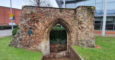
And, this was a former entrance to the barrack buildings, although it has been landscaped so there’s now nothing behind here other than soil. It’s also where the entrance to Hassett House would have been, and for a period of time, the tower over the other side of the Wensum River was known now as Cow Tower, but as Hassett Tower.


