Streets of Norwich – Redwell Street
Part of my Streets of Norwich project….
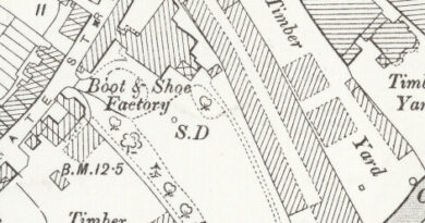
Redwell Street today doesn’t quite make sense, it goes from Princes Street at the top of the above map, down to Queen Street, which is where Brewdog is located.
Redwell Street makes more sense in this map from the 1880s, as some buildings were demolished to allow for St. Andrew’s Street to be extended, allowing trams to use the road. This cut Redwell Street in two and the lower half is really now part of St. Andrew’s Street in terms of the road layout.
The street used to be known as St. Michael’s Street, because of St. Michael-at-Plea Church which is located here. In the seventeenth century a pump was added to an existing well by the church, which likely had a red covering and surround, and it became known as Red Well Street. That, over time, became corrupted into the current name of Redwell Street.
This is Boardman House, which has a Redwell Street address, but its frontage and a connected building is on Princes Street, so more on that another time.
Not much of huge historic interest here, although the building on the far right is 8 Redwell Street, which retains its nineteenth century frontage.
The building on the right-hand side was built in 1957 for the Norfolk News Company, sadly demolishing a fair chunk of its heritage during the process. Given that the first provincial newspaper was published here at the beginning of the eighteenth century, it’s a shame that there’s nothing more than a plaque to mark the event.
This is the building to the right-hand side of Jackson-Stops, the entrance to Clement Court.
The signs show where Bank Plain and Redwell Street meet. The building on the right is interesting, this is 2 Redwell Street, which has a fifteenth century undercroft. The shopfront is original from the nineteenth century and the undercroft and cellars project underneath the Redwell Street pavement.


